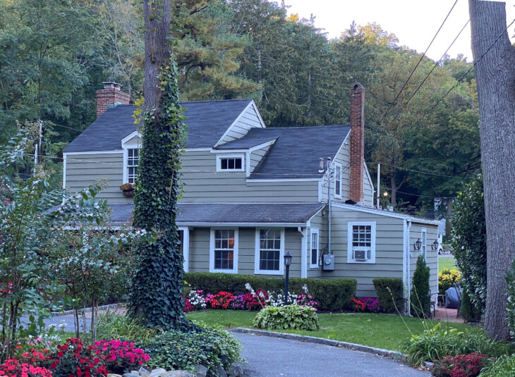
Kirby-Sammis House
244 East Broadway, Roslyn
Source: 1986 House Tour Guide (page 336)
Stage I: c. 1860-1910. The tiny house on the 1873 Beers, Comstock & Cline Map which later became the Kirby-Sammis House may have been erected by Captain Kirby as a tenant house, like its larger neighbor to the north which no longer exists. Their construction predated not only the publication of the 1873 map but maybe also that of the Walling Map which depicts Roslyn circa 1859.
The below earlier map locates two buildings within the Kirby triangle, as well as two structures on the west side of Main Street slightly to the south of the above and a building on the east side of East Broadway just before it is intersected by Main Street, ownership of the last three properties being denoted on the 1859 map by the name "J.M. Kirby." However, it is not possible to state with certainty that the southernmost of these buildings in the triangle at Kirby's Corners standing prior to 1859 was the structure which has been identified on the later 1873 map as the nucleus of the present Kirby-Sammis House.
Situated right at the edge of the west end of East Broadway, the little house, as seen in an old Kirby family photograph, faces roughly south. The photograph, taken from the west side of the continuation southward of Main Street past Kirby Corners, shows street car lines, which were installed in Roslyn circa 1908, but no fire hydrants, which were erected in conjunction with installations in about 1910 of a village water supply. (The telephone and electrical wires are also visible in the photograph, but they both pre-dated the above improvements, arriving in Roslyn in 1887 and 1901 respectively.) The architectural details of the little house which can be gleaned from this ca. 1908 photograph are as follows. It is a V/2 storey cottage with its roof ridge approximately parallel to East Broadway. Its shallow pitched roof appears to be covered with dark weathered wood shingles, the sides are sheathed with painted wood clapboards, and cornerboards are visible at the ends of the building. The width of the clapboards can be approximated by the fact that the ample ground floor window, from the top of its drip cap to the bottom of its sill, "measures" 7 clapboards high. The cottage is two bays wide at its south-facing street elevation, with a board-and-batten door at the west end, a 6/6 light window with double-hung sliding sash at the east end. In addition, there is a shed-roof wing of one storey, windowless, at the east end, sheathed in vertical boards divided at their vertical mid-points by a row of nail-heads. It clearly looks like a later addition to the "original" cottage. Since a metal stove pipe is visible projecting out of the roof, it is presumed this wing functioned as a kitchen. Its south wall is flush with that of the earlier main section of the cottage. From the outside, the cottage appears to have a "two [rooms] down, two up" plan, since the proportions suggest that it is two bays deep. The west elevation is partially obscured and only two windows, seemingly shuttered, are visible, both at the south end. The window on the second storey appears to be only about half as tall as the lower storey one.
Another Kirby photograph, probably from around the same date just prior to 1910, shows the roof and part of the east elevation of the kitchen wing. A small 6/6 window is located about in the middle of this outside wall, and the vertical boards sheathing the wing itself are unpainted. The roof of the wing looks very smooth and is possibly covered with tin. From the angle of this photograph, which was taken just outside the fence along East Broadway and which shows the east (street) facade and part of the south facade of the Captain Jacob M. Kirby Tenant House on Main Street in the background, it is clear that it was taken before the cottage was moved to the inside of the Kirby Corners triangle, from the edge of that property; see Stage II below. (Incidentally, several other historical photographs of Kirby Corners during the Stage I period of the Kirby-Sammis House are extant. Due to the angle, they do not show that particular building, but they reveal the presence, chiefly in outline form—the photographs are snow scenes—of the larger structure, just north of the cottage on the west side of East Broadway, which was depicted on the 1873 Beers, Comstock & Cline map.)
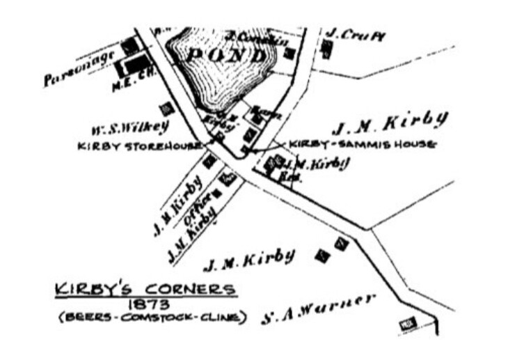
Map 1873
0 Comments