Tappan-Johnson House
1603 Northern Boulevard, Roslyn
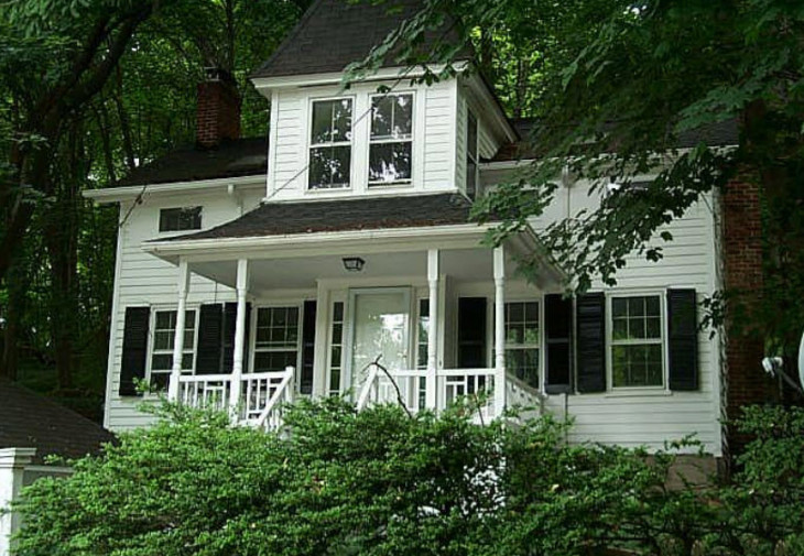
The Beers-Comstock Map (1859) shows six houses located on the north side of Northern Boulevard east of the present site of Trinity Church. Actually, the easternmost of these, the Caleb Kirby House, which still stands, should not be included in the group as it was, and is, located a considerable distance to the east. By the time the Beers-Comstock Map (1873) was published there were nine houses standing in place of the earlier five. There is only one owner common to both groups of houses. In the Walling Map "Mrs. Pearsall's" house (the present #1621) is shown standing as the fourth house from the west end of the group. In the Beers-Comstock Map (1873) the fourth house from the west end is shown as belonging to "Mary P. Pearsall", whom we consider to be the "Mrs. Pearsall" of the Walling Map. In the Walling Map the house immediately to the west of Mrs. Pearsall's house is shown as belonging to Mrs. Tappan. On the Beers-Comstock Map this house is shown as belonging to Dennis Powers. This house, today's #1603, is the subject to this article.
We do not know when Dennis Powers acquired the house but it was at some time between 1859 and 1873. On August 18,1888 he sold the house to Susan A. Johnson (Queens County Deeds Liber 752, Page 313). In 1907 Susan A. Johnson sold the property to Henry Abrams and Lizzie Abrams, his wife (Nassau County Deeds Liber 134, Page 234). On March 20,1923, the Abrams conveyed the house to John T. Wehner (Nassau County Deeds Liber 776, page 20). Mr. Wehner sold the property to James Hilton on February 6, 1929 (Nassau County Deeds Liber 1414, Page 243). On November 7,1945, Eva G. Hilton sold the house to Ethel Venableand Schula Alston (Nassau County Deeds Liber 8, Page 6) and on March 23,1978 Ethel Venable and Schula Alston, tenants-in-common, sold the property to Dorothy E. Lyon, the present owner (Nassau County Deeds Liber 9099, Page 783).
The deed to the property (1978) shows that it is bounded on the west by land now or formerly of James K. Davis (land previously owned by James Mott) and on the east by the land now or formerly of Jacob Pearsall, presumably an heir of Mary P. Pearsall. John Mott's holding, a single house, is shown on the Beers-Comstock Map (1873) directly to the west of D. Powers. In 1906, the Belcher-Hyde Map showed that James K. Davis had acquired James Mott's house and a double house immediately to the west of it (Queens County Deeds, Liber 820, page 15, May 1, 1890 and Nassau County Deeds Liber 204, Page 197, Nov. 3,1909). In addition, two double houses belonging to S.D. Replogle had been built immediately to the the west of the two James K. Davis houses. At that time the Trinity Church Parish House had not yet been built.
The Belcher-Hyde Map (1906) also shows the Tappan-Johnson house as belonging to Fred Engolf, although the title chain does not confirm this. The Sanborn Map of 1920 shows all of these houses up to and including the Tappan-Johnson house which was the fifth in line from the west. The Pearsall house immediately to the east of the Tappan-Johnson house had a large west side yard.
Circa 1925, Trinity Church apparently acquired the Replogle houses and demolished them to provide more room around its Parish House. At that time S.D. Replogle acquired the Pearsall side-yard east of the Tappan-Johnson house and built today's #1613. At some time after 1920, the late Childs Frick acquired the two Davis' houses which his estate demolished during the 1970's. The land upon which they stood was donated to Trinity Church. The sites of the entrances of all four of those westermost houses, i.e. two Replogle and two Davis, may readily be seen in the low curbside retaining wall which survives. This demolition today leaves the Tappan-Johnson house as the westernmost in the row of nine houses.
0 Comments